Pinterest

Thursday, July 31, 2014

Photos: Majestic thunderstorm lights up over Mt. Hood

Majestic thunderstorm forms over Mt. Hood Photos of a dramatic thunderstorm taken in the Columbia River Gorge July 22, 2014 at sunset. Photos are courtesy Darlisa Black, Starlisa.net.

click link above for photo series of storm development
http://www.komonews.com/weather/blogs/scott/Photos-Majestic-thunderstorm--269084221.html


Why Seattle doesn't see Eastern Wash. wildfire plumes until the afternoon

Published: Jul 30, 2014


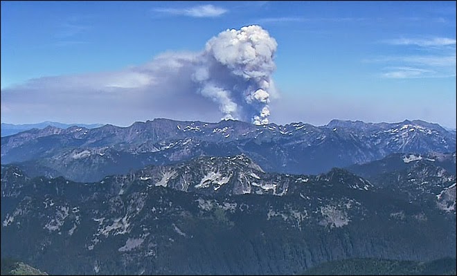
Local social media posts have been perking up each afternoon noting tall plumes of clouds over the Cascades. What you're seeing are smoke and the "pyrocumulus" clouds created by the wildfires burning in Eastern Washington. The heat from the fires is its own engine for creating rising air that cools and condenses into clouds.
But why don't we normally see those clouds over here until the afternoon?
There is a bit of an inversion in play in Eastern Washington, caused by sinking air aloft from high pressure and cooler air forming near the ground at night from clear skies allowing the day's heat to radiate back into space.

The morning weather balloon launched in Spokane Wednesday showed the temperature at the surface was 63 but was a whopping 84 degrees at 3,000 feet. It was a little warmer in Central Washington near the wildfires this morning, but you get the idea.                                                                                           Wildfire Plume over Eastern Washington

But as the day -- and the ground -- warms up, eventually this process reverses and the lid goes 'poof' allowing the hot air and smoke to roar to the skies, creating a vertical plume visible across much of the state.

amazing video of wildfire smoke movement http://www.komonews.com/weather/blogs/scott

Wednesday, July 30, 2014

How to Keep the Californians Out

Yes, the Northwest may well become a climate refuge during the upcoming century.  
The big question?  


How do we keep the Californians out?   One idea is shown below.
http://cliffmass.blogspot.com/

Tuesday, July 29, 2014

Will the Pacific Northwest be a Climate Refuge Under Global Warming?

Monday, July 28, 2014
Cliff Mass Weather Blog

As global warming takes hold later in the century, where will be the best place in the lower 48 states to escape its worst effects?

A compelling case can be made that the Pacific Northwest will be one of the best places to live as the earth warms.   A potential climate refuge.

Let's analyze this important question.

The anticipated issues, including sea level rise, water availability, hurricanes and tropical storms, heat waves and most other issues should not be problematic for the this area.

So what conclusion does one inevitably reach by studying the U.S. Climate Assessment, and the climate literature?

The Northwest is the place to be during global warming.   
  • Temperatures will rise more slowly than most of the nation due to the Pacific Ocean (see below)  
  • We will have plenty of precipitation, although the amount falling as snow will decline (will fall as rain instead).  But we can deal with that by building more reservoir and dam capacity (and some folks on the eastern slopes of the Cascades have proposed to do exactly that).
  • The Pacific Ocean will keep heat waves in check and we don't get hurricanes.
  • Sea level rise is less of a problem for us due to our substantial terrain and the general elevation rise of our shorelines.  Furthermore, some of our land is actually RISING relatively to the sea level because we are still recovering from the last ice age (the heavy ice sheets pushed the land down and now it is still rebounding).
  • There is no indication that our major storms...cyclone-based winds (like the Columbus Day Storm)... will increase under global warming.  
  • Increased precipitation may produce more flooding, but that will be limited to river valleys and can be planned for with better river management and zoning.


Saturday, July 26, 2014

Space Weather: Coronal Hole

A coronal hole, almost square in its shape, is one of the most noticeable features on the sun on May 5-7, 2014. A coronal hole is an area where high-speed solar wind streams into space. It appears dark in extreme ultraviolet light as there is less material to emit in these wavelengths. Inside the coronal hole you can see bright loops where the hot plasma outlines little pieces of the solar magnetic field sticking above the surface. Because it is positioned so far south on the sun, there is less chance that the solar wind stream will impact us here on Earth.


A coronal hole, almost square in its shape, is one of the most noticeable features on the sun on May 5-7, 2014. A coronal hole is an area where high-speed solar wind streams into space. It appears dark in extreme ultraviolet light as there is less material to emit in these wavelengths. Inside the coronal hole you can see bright loops where the hot plasma outlines little pieces of the solar magnetic field sticking above the surface. Because it is positioned so far south on the sun, there is less chance that the solar wind stream will impact us here on Earth.

Spectacular solar flares

NASA's Solar Dynamics Observatory (SDO), which observes the sun 24 hours a day, captured this image of a solar flare on June 10.http://www.cnn.com/2014/07/15/tech/innovation/space-weather-solar-flares/
NASA's Solar Dynamics Observatory (SDO), which observes the sun 24 hours a day, captured this image of a solar flare on June 10.

NASA captured this second flare, which appears as a bright flash on the left side of the sun, June 10.

NASA captured this second flare, which appears as a bright flash on the left side of the sun, June 10.

Space Weather: The sun is at "Solar Maximum", but activity labeled modest

The sun is currently at its "solar maximum" -- the point in its cycle where it is at peak activity -- but the SWPC says that activity is modest compared to recent cycles.

Nonetheless, last week the center reported that the sun had produced a "moderate-level" solar flare, which had "short-lived impacts to high frequency radio communications on the sunlit side of Earth."SDO's view of X1.4 class solar flare in the 304 wavelength.
Solar flares can send blasts of radiation through space that can interfere with satellites and even harm astronauts during spacewalks.
"So when an eruption happens -- when we have that flash of light, those radio waves -- that takes eight minutes to get from the sun to the Earth. So as soon as we start the measurement, it's already affecting the sunlit side of the Earth," explains Rutledge.
Innovations in spacecraft by NASA are showing us some of the best images of the sun we've ever seen -- giving us a clearer picture and hopefully a better understanding of space weather.


This close-up view of a prominence reveals magnetic forces at work as they pull plasma strands this way and that before it gradually breaks away from the sun over a one-day period November 14-15, 2011
This close-up view of a prominence reveals magnetic forces at work as they pull plasma strands this way and that before it gradually breaks away from the sun over a one-day period November 14-15, 2011.But there is still much mystery to the 4.5 billion-year-old star and the emissions that are blasted through space, so scientists and forecasters will continue to watch every movement.
Two areas of dark plasma that were close together danced and entwined with each other over a one-day period March 27-28, 2012. The dark plasma, seen in profile, was somewhat cooler and therefore darker than the material around it.


Two areas of dark plasma that were close together danced and entwined with each other over a one-day period March 27-28, 2012. The dark plasma, seen in profile, was somewhat cooler and therefore darker than the material around it.

Space weather: Fine, with a chance of solar flares

A mid-level flare erupted on the left side of the sun on July 8, 2014. This image from NASA's Solar Dynamics Observatory highlights the high-temperature solar material in a flare, which is typically colorized in teal.A mid-level flare erupted on the left side of the sun on July 8, 2014. This image from NASA's Solar Dynamics Observatory highlights the high-temperature solar material in a flare, which is typically colorized in teal.
The Art of Movement is a monthly show that highlights the most significant innovations in science and technology that are helping shape our modern world. Go inside "The Space Race" Thursday night on CNN's Original Series, "The Sixties."

Space Weather: Sun Watchers


A large active region is giving off warning signs that this could be the source of powerful solar storms. It has already shot off two smaller flares (Jan. 2, 2014) as shown here in a wavelength of extreme ultraviolet light.

A large active region is giving off warning signs that this could be the source of powerful solar storms. It has already shot off two smaller flares (Jan. 2, 2014) as shown here in a wavelength of extreme ultraviolet light.

  • Space Weather Prediction Center watches skies for solar activity

Boulder, Colorado (CNN) -- From Earth, the sun appears as a constant circle of light, but when viewed in space a brilliant display of motion is revealed.
Flares that light up the galaxy and eruptions that can be as large as 30 times the Earth's surface occur regularly. During the peak of the 11-year solar cycle, these events can happen several times a day.
The flares and eruptions are collectively known as space weather and although they create dazzling visuals in space, it isn't just a harmless fireworks show for the galaxy. Each burst of energy can have a disrupting effect on systems we rely on every day.
With their headquarters next to the Rocky Mountains in the state of Colorado, a team of forecasters aims to minimize that impact.
"The Space Weather Prediction Center (SWPC) essentially watches the sun, watches for activity on the sun originating from sun spots," explains Bob Rutledge, Forecast Office lead.
"That's really where the magnetic fields of the sun poke through the surface and kind of hold that part of the surface in place allowing it to cool -- that's why it appears dark."
This image from the Solar Dynamics Observatory shows the sun on July 12, 2012 during an X1.4 class flare. The image is captured in the 304 Angstrom wavelength, which is typically colorized in red.This image from the Solar Dynamics Observatory shows the sun on July 12, 2012 during an X1.4 class flare. The image is captured in the 304 Angstrom wavelength, which is typically colorized in red.

This image combines two sets of observations of the sun on July 12, 2012 from the SDO to give an impression of what the sun looked like shortly before it unleashed an X-class flare.This image combines two sets of observations of the sun on July 12, 2012 from the SDO to give an impression of what the sun looked like shortly before it unleashed an X-class flare.

Gas rolls up and down the sun's outer layer, similar to the bubbles in boiling water. When the magnetic field around a sun spot breaks, magnetic energy explodes in the solar atmosphere like a pot boiling over.
The size and position of sun spots can give forecasters a clue as to when or where a solar flare may bubble up. They produce daily forecasts that are important to the industries most vulnerable.
"Space weather can have a variety of impacts across many different customer bases -- commercial aviation, precision GPS use, power grid operations -- all these are really critical," says Rutled
Active Region 1514 just could not contain itself as it popped off over a dozen flashes, minor eruptions, and flares over almost two days June 27-29, 2012.
Two areas of dark plasma that were close together danced and entwined with each other over a one-day period March 27-28, 2012. The dark plasma, seen in profile, was somewhat cooler and therefore darker than the material around it.


Clearwater River Log Drives


http://www.youtube.com/watch?v=GJKDp58qDqI


Watch this great video of the crews and equipment used on the Clearwater River log drives
from 1928 to 1971


Wednesday, July 23, 2014

Watch Fiona's Story - Toddler Transplant Fund Video on Youtube

IN THE WORDS OF HER MOTHER. Fiona's Fight is nothing short of miraculous.  As painful weekly treatments continue to keep her going for now, a bone marrow transplant is the only cure that can bring this adorable little girl the gift of a normal life.  Watch Fiona's story, in the words of her mother, Karen.  Video donated by Siwel Productions.
https://www.youtube.com/watch?v=EzvM0n0Xp5I

Friday, July 18, 2014

MOLD

Thursday, July 17, 2014

As we've been pulling out carpet we've been finding spots of mold. We're working on treating it, running a dehumidifier, and finding sources of moisture. The spray we're using prevents mold from growing back. We'll probably need to have our heating and cooling ducts cleaned. Yuck! Fiona is on Diflucan to prevent thrush, so she has some protection. Have I ever mentioned that this is not my favorite house? It's not.

Toddler Transplant Fund

We are overwhelmed with the cost of medical bills, trips to Cincinnati, and the things we need to keep Fiona healthy. We have tried for the past few months to put the maximum amount of money into our health savings account to pay for Fiona's care. We could just manage it until we had to repair our sewer line. Every donation goes directly to pay for Fiona's care. We are hoping to raise enough to take care of a mold problem in our kitchen, pay for this year's medical bills, and keep enough to pay for next year's insurance out of pocket. Please donate if you can, and share her fundraiser.

Thursday, July 17, 2014

Having a Life

Fi's mommy's post from Tuesday, April 15, 2014

having a life...
Yesterday our transplant coordinator said that somehow Fiona needs to have a life. She needs to get out. He said he thinks that we can take her to the zoo. Once it warms up a little we can take her outside, before 10am, and after 4pm (she can't be in the sun too much because of her antibiotic). Trying to protect a 2 year old from the world is a hard thing. She just wants to run and play. I just want to keep her healthy
http://www.gofundme.com/shesafightercom
Share & Donate if you can Fiona's Transplant Fund

HOW HOT WAS IT? Lewiston/Clarkston 105, Cashmere 108

NATIONAL WEATHER SERVICE SPOKANE WA
HIGH TEMPERATURE REPORTS JULY 16, 2014...

LOCATION                       TEMP      TIME/DATE

...IDAHO...

...BONNER...
PRIEST LAKE              94 F      0508 PM 07/16
SPIRIT LAKE               93 F      0510 PM 07/16
SANDPOINT                      90 F      0335 PM 07/16

BOUNDARY...
BONNERS FERRY            99 F      0237 PM 07/16

KOOTENAI...
2 ENE RATHDRUM                 101 F     0421 PM 07/16
POST FALLS                     100 F     0400 PM 07/16
COEUR D ALENE AIR TERMINAL AIR 97 F      0455 PM 07/16

LATAH...
MOSCOW                     98 F      0357 PM 07/16
DEARY                     96 F      0400 PM 07/16
LEWIS...
KAMIAH                         98 F      0400 PM 07/16
MISSION CREEK             94 F      0403 PM 07/16
WINCHESTER ITD            91 F      0330 PM 07/16

...NEZ PERCE...
2 N LEWISTON                   105 F     0333 PM 07/16
LEWISTON AP                    104 F     0456 PM 07/16
5 S JULIAETTA ITD              104 F     0315 PM 07/16
1 ENE CLARKSTON                102 F     0324 PM 07/16
6 ESE WAHA                     101 F     0415 PM 07/16
4 ENE LEWISTON                 101 F     0603 PM 07/16
RSVR A (LEWISTON ORCHARDS)     97 F      0545 PM 07/16
3 SSW GENESEE                  96 F      0345 PM 07/16
2 NNE REUBENS                  93 F      0331 PM 07/16

...SHOSHONE…
KELLOGG                        97 F      0339 PM 07/16
WALLACE                91 F      0315 PM 07/16

.WASHINGTON...

.ADAMS...
OTHELLO                105 F     0429 PM 07/16
WASHTUCNA                103 F     0317 PM 07/16

...ASOTIN...
CLARKSTON HEIGHTS        105 F     0400 PM 07/16
ASOTIN  100 F     0515 PM 07/16

...CHELAN...
CASHMERE                       108 F     0315 PM 07/16
CHELAN                   107 F     0324 PM 07/16
CASHMERE                       107 F     0315 PM 07/16
NW WENATCHEE                 105 F     0355 PM 07/16
WENATCHEE                      103 F     0500 PM 07/16
LEAVENWORTH                    103 F     0345 PM 07/16
WENATCHEE                 94 F      0334 PM 07/16

GARFIELD...
POMEROY                        99 F      0420 PM 07/16

GRANT...
GRAND COULEE                   107 F     0325 PM 07/16
GEORGE                   107 F     0420 PM 07/16
MOSES LAKE               106 F     0443 PM 07/16
EPHRATA                                     106 F    
ROYAL CITY                102 F     0400 PM 07/16
COULEE DAM                100 F     0600 PM 07/16

SPOKANE...
2 SE SPOKANE                   105 F     0405 PM 07/16
FELTS FIELD AIRPORT            101 F     0453 PM 07/16
MEAD                     101 F     0400 PM 07/16
OTIS ORCHARDS                  100 F     0415 PM 07/16
SPOKANE                    100 F     0500 PM 07/16
SPANGLE                  99 F      0400 PM 07/16
SPOKANE INTL AP                99 F      0453 PM 07/16
OPPORTUNITY                    99 F      0424 PM 07/16
SPOKANE 17 SSW              98 F      0400 PM 07/16
FAIRCHILD AFB             98 F      0358 PM 07/16
SPOKANE                        97 F      1200 AM 07/17
AIRWAY HEIGHTS            97 F      0333 PM 07/16
DEER PARK                      97 F      1253 AM 07/17                                                                                          

LIBERTY LAKE                   97 F      0600 PM 07/16

STEVENS...
KETTLE FALLS                   106 F     0437 PM 07/16
COLVILLE                                    104 F     0445 PM 07/16

WHITMAN...
PULLMAN                   99 F      0321 PM
UNIONTOWN                  98 F      0200 PM 07/16
PULLMAN/MOSCOW REGIONAL AIRPOR 98   07/16
COLTON                         98 F      0437 PM 07/16

SUPER WARM WEDNESDAY

Weather Story (click the image for a higher resolution image).
Wednesday, July 16, 2014 was a hot one across the Inland Northwest. This image depicts the maximum temperatures recorded at many automated weather stations across the region

BAD AIR

Weather Story (click the image for a higher resolution image).
Smoke from area wildfires will continue to affect the air quality around the Inland Northwest. Two large wildfires burning in the Okanogan-Wenatchee National Forest continue to send plumes of smoke across central and eastern Washington. The smoke gets trapped beneath a low level inversion during the overnight and early morning hours, then mixes into the atmosphere during the afternoon. Expect air quality to continue to deteriorate as the wildfires continue to put out smoke plumes.

Relief from the Heat

Expect more July-like temperatures over the weekendBreezy westerly winds will blow a cooling trend….and more wildfire smoke.


FRIDAY: Sunny skies - morning low 62 degrees, west winds 5-15 mph, afternoon high temperature 94 degrees.
SATURDAY: Sunny skies, west winds 5-10 mph, morning low 64, afternoon high 90.
SUNDAY: Mostly sunny, west wind 12 mph, morning low 65, afternoon high 89.
MONDAY: Mostly sunny, morning low 63, afternoon high 89.
TUESDAY: Sunny 93 degrees.
WEDNESDAY: Partly cloudy 89, mainly mountain showers.

Most Popular Posts This Month