Pinterest

Thursday, July 31, 2014

Photos: Majestic thunderstorm lights up over Mt. Hood

Majestic thunderstorm forms over Mt. Hood Photos of a dramatic thunderstorm taken in the Columbia River Gorge July 22, 2014 at sunset. Photos are courtesy Darlisa Black, Starlisa.net.

click link above for photo series of storm development
http://www.komonews.com/weather/blogs/scott/Photos-Majestic-thunderstorm--269084221.html


Why Seattle doesn't see Eastern Wash. wildfire plumes until the afternoon

Published: Jul 30, 2014


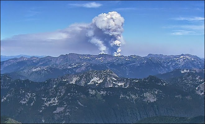
Local social media posts have been perking up each afternoon noting tall plumes of clouds over the Cascades. What you're seeing are smoke and the "pyrocumulus" clouds created by the wildfires burning in Eastern Washington. The heat from the fires is its own engine for creating rising air that cools and condenses into clouds.
But why don't we normally see those clouds over here until the afternoon?
There is a bit of an inversion in play in Eastern Washington, caused by sinking air aloft from high pressure and cooler air forming near the ground at night from clear skies allowing the day's heat to radiate back into space.

The morning weather balloon launched in Spokane Wednesday showed the temperature at the surface was 63 but was a whopping 84 degrees at 3,000 feet. It was a little warmer in Central Washington near the wildfires this morning, but you get the idea.                                                                                           Wildfire Plume over Eastern Washington

But as the day -- and the ground -- warms up, eventually this process reverses and the lid goes 'poof' allowing the hot air and smoke to roar to the skies, creating a vertical plume visible across much of the state.

amazing video of wildfire smoke movement http://www.komonews.com/weather/blogs/scott

Wednesday, July 30, 2014

How to Keep the Californians Out

Yes, the Northwest may well become a climate refuge during the upcoming century.  
The big question?  


How do we keep the Californians out?   One idea is shown below.
http://cliffmass.blogspot.com/

Tuesday, July 29, 2014

Will the Pacific Northwest be a Climate Refuge Under Global Warming?

Monday, July 28, 2014
Cliff Mass Weather Blog

As global warming takes hold later in the century, where will be the best place in the lower 48 states to escape its worst effects?

A compelling case can be made that the Pacific Northwest will be one of the best places to live as the earth warms.   A potential climate refuge.

Let's analyze this important question.

The anticipated issues, including sea level rise, water availability, hurricanes and tropical storms, heat waves and most other issues should not be problematic for the this area.

So what conclusion does one inevitably reach by studying the U.S. Climate Assessment, and the climate literature?

The Northwest is the place to be during global warming.   
  • Temperatures will rise more slowly than most of the nation due to the Pacific Ocean (see below)  
  • We will have plenty of precipitation, although the amount falling as snow will decline (will fall as rain instead).  But we can deal with that by building more reservoir and dam capacity (and some folks on the eastern slopes of the Cascades have proposed to do exactly that).
  • The Pacific Ocean will keep heat waves in check and we don't get hurricanes.
  • Sea level rise is less of a problem for us due to our substantial terrain and the general elevation rise of our shorelines.  Furthermore, some of our land is actually RISING relatively to the sea level because we are still recovering from the last ice age (the heavy ice sheets pushed the land down and now it is still rebounding).
  • There is no indication that our major storms...cyclone-based winds (like the Columbus Day Storm)... will increase under global warming.  
  • Increased precipitation may produce more flooding, but that will be limited to river valleys and can be planned for with better river management and zoning.


Saturday, July 26, 2014

Space Weather: Coronal Hole

A coronal hole, almost square in its shape, is one of the most noticeable features on the sun on May 5-7, 2014. A coronal hole is an area where high-speed solar wind streams into space. It appears dark in extreme ultraviolet light as there is less material to emit in these wavelengths. Inside the coronal hole you can see bright loops where the hot plasma outlines little pieces of the solar magnetic field sticking above the surface. Because it is positioned so far south on the sun, there is less chance that the solar wind stream will impact us here on Earth.


A coronal hole, almost square in its shape, is one of the most noticeable features on the sun on May 5-7, 2014. A coronal hole is an area where high-speed solar wind streams into space. It appears dark in extreme ultraviolet light as there is less material to emit in these wavelengths. Inside the coronal hole you can see bright loops where the hot plasma outlines little pieces of the solar magnetic field sticking above the surface. Because it is positioned so far south on the sun, there is less chance that the solar wind stream will impact us here on Earth.

Spectacular solar flares

NASA's Solar Dynamics Observatory (SDO), which observes the sun 24 hours a day, captured this image of a solar flare on June 10.http://www.cnn.com/2014/07/15/tech/innovation/space-weather-solar-flares/
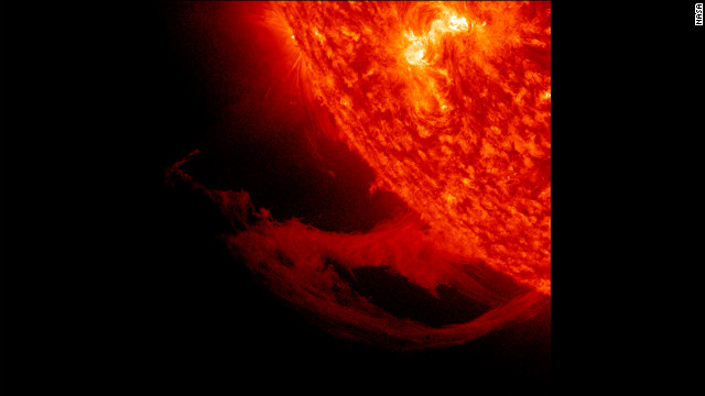
NASA's Solar Dynamics Observatory (SDO), which observes the sun 24 hours a day, captured this image of a solar flare on June 10.

NASA captured this second flare, which appears as a bright flash on the left side of the sun, June 10.

NASA captured this second flare, which appears as a bright flash on the left side of the sun, June 10.

Space Weather: The sun is at "Solar Maximum", but activity labeled modest

The sun is currently at its "solar maximum" -- the point in its cycle where it is at peak activity -- but the SWPC says that activity is modest compared to recent cycles.

Nonetheless, last week the center reported that the sun had produced a "moderate-level" solar flare, which had "short-lived impacts to high frequency radio communications on the sunlit side of Earth."SDO's view of X1.4 class solar flare in the 304 wavelength.
Solar flares can send blasts of radiation through space that can interfere with satellites and even harm astronauts during spacewalks.
"So when an eruption happens -- when we have that flash of light, those radio waves -- that takes eight minutes to get from the sun to the Earth. So as soon as we start the measurement, it's already affecting the sunlit side of the Earth," explains Rutledge.
Innovations in spacecraft by NASA are showing us some of the best images of the sun we've ever seen -- giving us a clearer picture and hopefully a better understanding of space weather.


This close-up view of a prominence reveals magnetic forces at work as they pull plasma strands this way and that before it gradually breaks away from the sun over a one-day period November 14-15, 2011
This close-up view of a prominence reveals magnetic forces at work as they pull plasma strands this way and that before it gradually breaks away from the sun over a one-day period November 14-15, 2011.But there is still much mystery to the 4.5 billion-year-old star and the emissions that are blasted through space, so scientists and forecasters will continue to watch every movement.
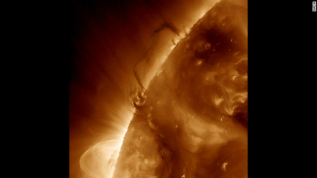
Two areas of dark plasma that were close together danced and entwined with each other over a one-day period March 27-28, 2012. The dark plasma, seen in profile, was somewhat cooler and therefore darker than the material around it.


Two areas of dark plasma that were close together danced and entwined with each other over a one-day period March 27-28, 2012. The dark plasma, seen in profile, was somewhat cooler and therefore darker than the material around it.

Most Popular Posts This Month