Pinterest

Sunday, April 26, 2015

Exploding Trees and Lightning

Cliff Mass Weather Blog Sat. April 25, 2015

If you needed another reason to avoid standing under a tree during a lightning storm, here is another: the tree might explode and shred everything in its environment. 

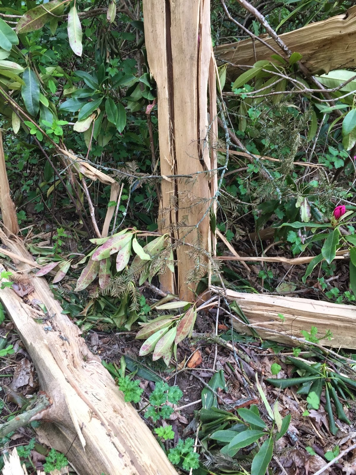
Such an event happened in the University of Washington Arboretum on March 31st and I visited the site this week during a run.....and I was amazed.   Here I am in front of the tree... this tall fir blew out form the center, with spokes of the trunk projecting out on the ground likes spokes of a bicycle wheel (picture taken by my colleague Lyatt Jaegle).


 Branches and tree shrapnel was obvious HUNDREDS OF FEET from the tree.   Some of the wood was ejected so forcefully that it hit the ground and was deeply embedded--- over 100 feet away!   So deep I could not pull it out.

A view from the air (courtesy of KOMO TV) and on the ground right after it happened (courtesy of the UW arboretum)  are shown below.  The original tree was over 100 ft tall.


Why did it explode?  When lightning hits the tree, it ran down the moist inner sapwood, since that portion of the tree conducts current better.   The huge current produced rapid heating and the water turned to steam, which in turn produced huge pressures that caused explosive expansion.

Can you imagine if you were standing near that tree?  You would have been torn apart or speared by flying debris.   Of course, standing under a tree during a thunderstorm is a bad idea for other reasons, such as getting electrocuted by the lightning current.   When I was a student at Cornell, a bunch of student were sheltering under a tree during a storm.  Lightning hit.  Several were seriously injured with some never recovering.

Friday, April 17, 2015

BASEBALL WEATHER...its in the wind


It's only the second week of the baseball season and already radio and television announcers are bobbling what should be easy weather ground-balls. The most egregious errors are usually misstatements about the humidity and why the ball doesn't go as far.  NOT!

The difference in the distance a 375 foot homerun travels when the humidity is 20% and when it is 60% is less than a foot.  And the difference in the amount that a 90 mph curveball breaks is only a tenth of an inch. (There may be some absorption of moisture by a baseball on a particularly muggy day, but those amounts have been found to also be negligible).

The temperature (and thus the air density) has a slightly greater impact with the difference in the distance of a home run on a 50 degree day being about 16 feet less than on a 90 degree day.  The altitude above sea level and corresponding air lower density difference means a 375 foot homer at sea level would travel about 405 feet at Coors Field in Denver.

But the meteorological element with the greatest impact is the wind.  Just a 5 mph tailwind will carry that 375 foot home run to 415 feet and a 10 mph wind will translate to an epic 455 foot blast.

The bottom line is that if you want to see really long homeruns go to Denver on a hot dry day with the wind blowing out!

A more detailed treatment of the topic can be found in last year’s Jan/Feb issue of Weatherwise Magazine (http://www.weatherwise.org/Archives/Back%20Issues/2014/January-February%202014/rain-delays-full.html )

Play ball.
 
Jan Null, CCM
Golden Gate Weather Service
http://ggweather.com

Tuesday, January 27, 2015

Hurricane Force wind Gusts = Not really a thing

I've heard this term (which makes me wince each time) quite a lot on news channels describing the "Blizzard of 2015".  The following is a 2011 article by my friend,
weather guru, Jan Null:

It seems that anytime there is a wind gust over about 60 mph the airwaves and other sources,
including NWS statements, are rife with the expression “hurricane force” winds. While this
might be good for conveying that it’s windy and might be dangerous, it’s both bad meteorology
and bad physics! (And calling it a hurricane force gust doesn’t make it right either)
Let’s start with some basics. The threshold for hurricane winds is when the 1-
minute sustained winds equal or exceed 74 miles per hour. Please note the word
“sustained”! According to the NOAA Hurricane Research Division, peak 3 to 5-
second gusts are approximately 30% higher than their associated sustained winds.
This means that a 74 mph sustained wind of a minimal hurricane has gusts in the
range of 96 mph. Quite a difference.

But that’s just the wind speed. What about the amount of force from the wind onto a surface that
is perpendicular to the wind? From high school physics we remember that the force associated
with a given speed is proportional to the square of the wind speed. (For the over achievers out
there, the formula to calculate this force is: F = .00256 x V^2, where F is the force in pounds per
square foot (psf), and V is the wind velocity in mph) Consequently, the amount of force with a
74 mph gust is 14.0 psf, while the force from a 96 mph gust is 23.6 psf; or 69% higher.
The bottom line is that a gust to 74 mph is NOT even close to hurricane force!
http://www.examiner.com/weather-in-san-francisco/meteorological-pet-peeves-part-1-of-3.
<><><><><><><><><><><><><><><><><>
Jan Null
Certified Consulting Meteorologist
Golden Gate Weather Services
Phone: (408) 379-7500
Email: jnull@ggweather.com
Webpage: http://ggweather.com
"Climate is what you expect,
Weather is what you get". ~ R. Heinlein
<><><><><><><><><><><><><><><><><>

Saturday, January 3, 2015

New Steelhead Season in Idaho starts with Best Run in Years

LEWISTON, ID - January first is not only the start of a new year, it's also opening day for a new steelhead season in Idaho.

With the new season, fishermen are reminded they need to buy a new license and a new steelhead tag.

This is different from Washington, where fishermen buy their licenses in the spring.

With the new season in Idaho, the limits are raised to three per-day and nine in possession. And there is good news for anglers, this is expected to be an excellent run.

"In fact, if you look at counts over Lower Granite Dam, we have about 20,000 steelhead destined for the Clearwater and if you want to compare that to previous years, last year we only had 8,000 at the same time," said Joe Dupont with the Idaho Fish and Game. "So quite a difference and two years ago we had 13,000 so it's a very good year when compared to the past few years." 

Another reminder for steelhead fishermen is that you can only use barbless hooks and may only keep hatchery steelhead marked with a clipped adipose fin. All other steelhead must

be released

Friday, January 2, 2015

Incredible sunrise over Mt. Hood Friday

Amazing sunrise over Mt. Hood Friday
The sunrise over Mt. Hood was spectacular Friday morning, Jan. 2, 2015. (Photo: Tyler Mode)

see more incredible NW pictues  http://ow.ly/GIXqE 

Sunday, December 28, 2014

NW Weather-Monday NIght: Bitterly Cold Wind Chills

The region will experience a period of bitterly cold wind chill temperatures Monday Night. Frigid overnight lows coupled with persistent winds will lead to downright raw conditions. The entire region will see values fall to or below zero. Locations in the Idaho Panhandle will fall to near -20F. Be prepared for the conditions if you will be outdoors Monday Night

Most Popular Posts This Month