Pinterest

Thursday, May 28, 2015

Watch: Time lapse video of gorgeous Mt. Rainier lenticular cloud

By  Published:   May 26, 2015

They're sometimes mistaken for aliens, but really, it's just a sign rain might be on the way.

Luke Meyers just recently published this time lapse video of a rather strange-looking lenticular cloud over Mt. Rainier last March. It's a good illustration of how they form -- the clouds look stationary but there's quite a bit of movement in them as air rises just enough to saturate, then dries enough as it sinks to "go invisible" again.

Here is another recent photo, taken by YouNews contributor "troxa41622511086":
Find out more about lenticular clouds here

Monday, May 18, 2015

Mount St. Helens - Pictures During and after

      Mount St. Helens Eruption - May 18, 1980 8;32 am                                      

Mount St. Helens erupted on May 18, 1980 in Skamania County, Wash. It was the deadliest eruption in U.S. history, killing 57 people. (left) Jim Valance, Cascades Volcano Observatory, U.S. Geological Survey (right)


Mount Saint Helens erupts. USGS via Earth Science World Image Bank (above)

Mount St. Helens sends a plume of ash, smoke and debris skyward. The eruption blasted more than 1,300 feet off the mountain's peak. Jack Smith, AP
The Initial Blast  (right) The mushroom cloud of volcanic ash produced by the eruption, as seen from Toledo, Washington, 35 miles away. The cloud was roughly 40 miles wide and 15 miles high.


Ash cloud as seen from space (below)
from Weather Satellite GOES-3 at 1545 UTC


map of eruption depostits

Sequence of events on May 18


NASA Satellite Image Mount St. Helens 35 Years After Its Historic Eruption


This satellite image of Mount St. Helens comes courtesy of NASA’s Earth Observatory


Today is the 35th anniversary of the volcano’s eruption and subsequent landslide, which killed 57 people. Scientists still keep a close watch on the site from both the air and ground.
As NASA notes:
The volcano has been quiet since 2008, which marked the end of a four-year period of activity.

Thursday, May 14, 2015

Snohomish storm chaser gets 1-in-a-million shot of tornado, rainbow

By Published: May 11, 2015


Not sure I've ever seen a photograph that captures the beauty and power of weather in one singular shot.

Snohomish's Benjamin Jurkovich, part of the JWSevere Weather Chasing Team has been out storm chasing in the Midwest for the past few weeks and he's had his share of twisters, super cells, and other images that define Tornado Alley in the spring.

But this one he got near Wiley, Colorado Saturday afternoon might be the most unique in his portfolio -- a tornado at the same time as a rainbow.

"It was pretty darn awesome!" he said.

Jurkovich said most of his storm chases have been in the dusty Midwest as it hadn't rained much, but the night before this photograph, that portion of Colorado had heavy rains, helping to clear the air for this spectacular shot.


He's been lucky so far in not having too many close calls - the one exception was while chasing a storm near Hayes, Kansas, another area of rotation began to develop to their southwest moving northeast:

read the rest of the story at http://ow.ly/MV75N


Wednesday, May 13, 2015

Salmon fishing open one last weekend on Lower Clearwater

By Published: May 13, 2015

CLARKSTON, WA - Idaho Department of Fish and Game is closing salmon fishing on the Lower Clearwater River this Sunday, from the Camas Prairie Railroad Bridge to Cherry Lane Bridge. Fishing ends at 8:30 that night.

Salmon fishing in the Clarkston area is now closed.

The Washington Department of Fish and Wildlife made the decision a little earlier than usual this season.

"Little Goose Fishery, Lower Granite Fishery and Clarkston Fishery remained open this last weekend," said WDFW Fish Biologist, Jeremy Trump. "We saw some really high catch rates and effort at Little Goose and Clarkston. We have reached our harvest target for this season, for the Snake River."

Trump said a total of 1,749 fish have been harvested this season.

Sunday, April 26, 2015

Exploding Trees and Lightning

Cliff Mass Weather Blog Sat. April 25, 2015

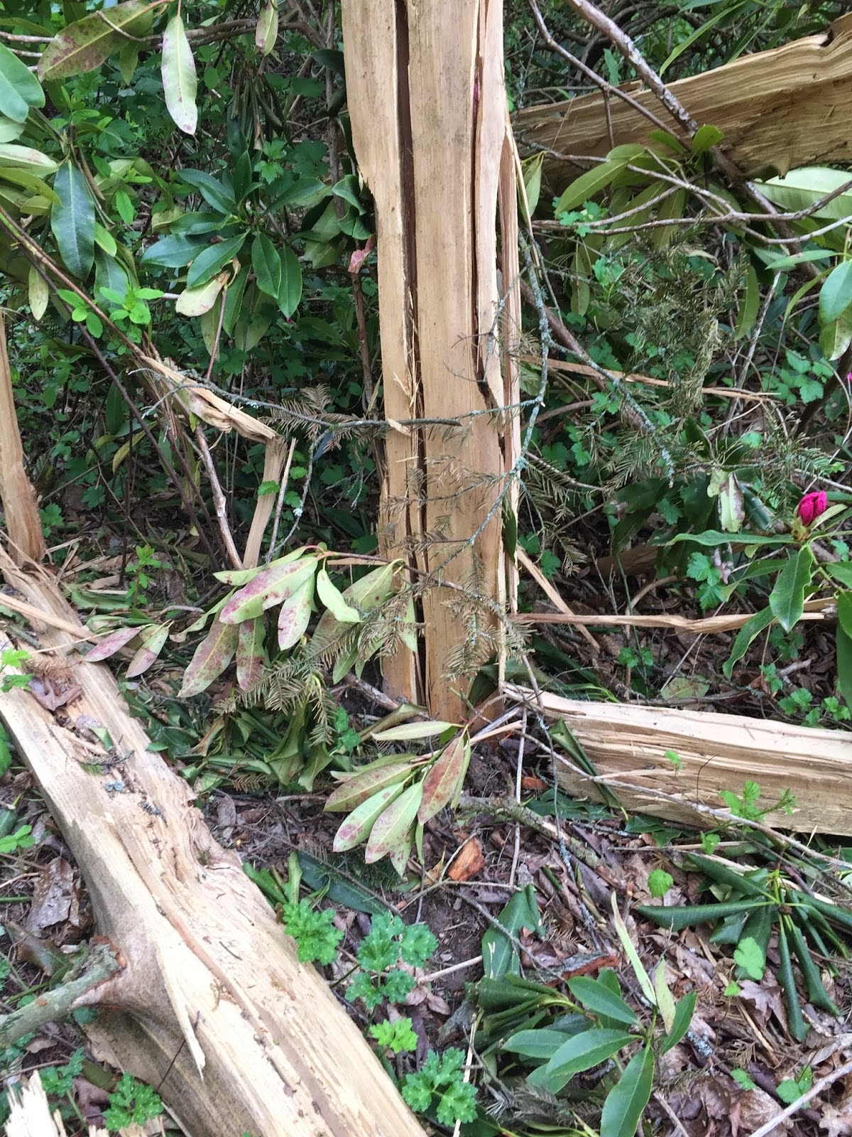
If you needed another reason to avoid standing under a tree during a lightning storm, here is another: the tree might explode and shred everything in its environment. 

Such an event happened in the University of Washington Arboretum on March 31st and I visited the site this week during a run.....and I was amazed.   Here I am in front of the tree... this tall fir blew out form the center, with spokes of the trunk projecting out on the ground likes spokes of a bicycle wheel (picture taken by my colleague Lyatt Jaegle).


 Branches and tree shrapnel was obvious HUNDREDS OF FEET from the tree.   Some of the wood was ejected so forcefully that it hit the ground and was deeply embedded--- over 100 feet away!   So deep I could not pull it out.

A view from the air (courtesy of KOMO TV) and on the ground right after it happened (courtesy of the UW arboretum)  are shown below.  The original tree was over 100 ft tall.


Why did it explode?  When lightning hits the tree, it ran down the moist inner sapwood, since that portion of the tree conducts current better.   The huge current produced rapid heating and the water turned to steam, which in turn produced huge pressures that caused explosive expansion.

Can you imagine if you were standing near that tree?  You would have been torn apart or speared by flying debris.   Of course, standing under a tree during a thunderstorm is a bad idea for other reasons, such as getting electrocuted by the lightning current.   When I was a student at Cornell, a bunch of student were sheltering under a tree during a storm.  Lightning hit.  Several were seriously injured with some never recovering.

Friday, April 17, 2015

BASEBALL WEATHER...its in the wind


It's only the second week of the baseball season and already radio and television announcers are bobbling what should be easy weather ground-balls. The most egregious errors are usually misstatements about the humidity and why the ball doesn't go as far.  NOT!

The difference in the distance a 375 foot homerun travels when the humidity is 20% and when it is 60% is less than a foot.  And the difference in the amount that a 90 mph curveball breaks is only a tenth of an inch. (There may be some absorption of moisture by a baseball on a particularly muggy day, but those amounts have been found to also be negligible).

The temperature (and thus the air density) has a slightly greater impact with the difference in the distance of a home run on a 50 degree day being about 16 feet less than on a 90 degree day.  The altitude above sea level and corresponding air lower density difference means a 375 foot homer at sea level would travel about 405 feet at Coors Field in Denver.

But the meteorological element with the greatest impact is the wind.  Just a 5 mph tailwind will carry that 375 foot home run to 415 feet and a 10 mph wind will translate to an epic 455 foot blast.

The bottom line is that if you want to see really long homeruns go to Denver on a hot dry day with the wind blowing out!

A more detailed treatment of the topic can be found in last year’s Jan/Feb issue of Weatherwise Magazine (http://www.weatherwise.org/Archives/Back%20Issues/2014/January-February%202014/rain-delays-full.html )

Play ball.
 
Jan Null, CCM
Golden Gate Weather Service
http://ggweather.com

Most Popular Posts This Month